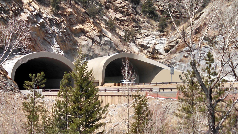
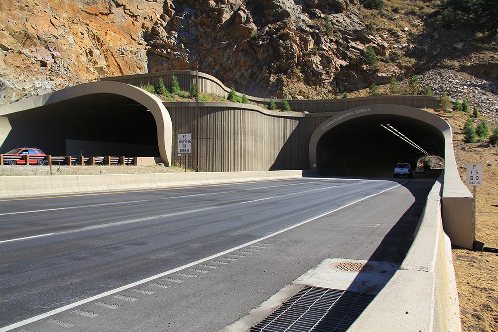
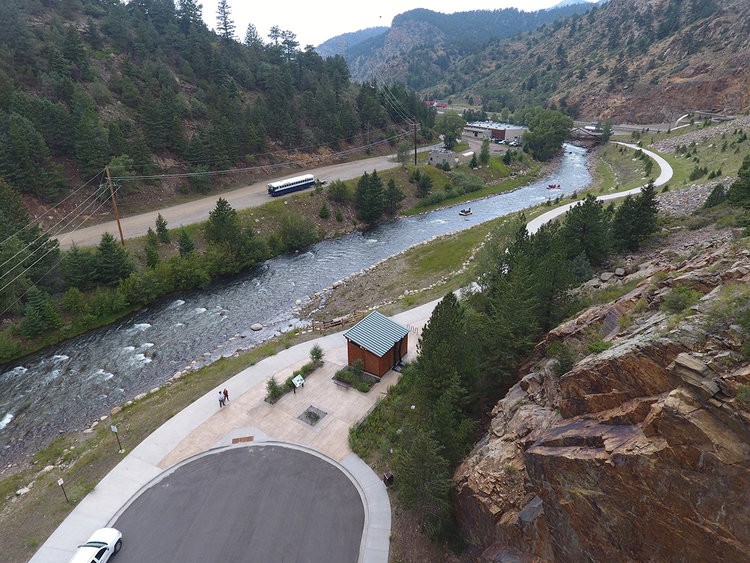
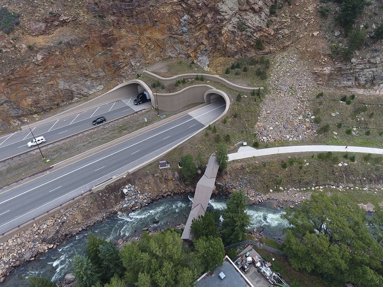
Veterans Memorial Tunnels
Beginning in 2012, THK was contracted to develop the architectural design for the Veterans Memorial Tunnels portals and landscape restoration of the mountain slopes. These tunnels replaced poorly functioning tunnels originally constructed in the 1960’s. Completed in October of 2015, the Veterans Memorial Tunnels widened both the east and west tunnel bores, from two lanes in each direction to three lanes, providing significant traffic mobility improvements to the I-70 Mountain Corridor.
A major traffic mobility issue with the existing tunnels was the ‘black hole’ effect that slowed traffic approaching the tunnel entrance. The ‘black hole’ physiological phenomenon occurs due to the visual contrast between the lighter colored tunnel head walls (portals) and the darkness of the tunnel. THK designed the tunnel portals and the landscape restoration around the tunnel portals to reduce the visual contrast between the tunnel, tunnel portals and mountain side. The amount of tunnel portal visible to the approaching motorists was minimized and the restored mountain side was darkened with evergreen vegetation. Increased lighting within the tunnel was also added to reduce the visual contrast.
Additionally, the flat tunnel head walls were replaced with a spiral designed structure where the tunnel hood transitioned into a 200 foot long wing wall that extends out to meet the approaching motorists to draw the traffic into the tunnel. The spiral wing walls double as a sound attenuation wall for the trailhead and rockfall protection for the I-70 motorists. THK utilized 3-D visualization tools to design the tunnel portals and the mountain slope restoration. The 3-D modeling created by THK allowed the design team to study different design concepts by simulating the drivers experience as they approached the tunnel. Traffic engineers, roadway engineers, geotechnical engineers, tunnel engineers and THK’s landscape architects worked to refine THK’s concepts for the tunnel portals to best meet mobility and safety goals. Numerous configurations were explored very quickly and very easily presented to stakeholders and decision makers to achieve the best solution in under a month.
The whole project, from environmental clearances through final construction, was completed in a little over four years.
Client
Location
Services

Related Projects
Downtown Chesterfield Park
THK Associates is working with the Staenberg Group to create the Downtown Chesterfield Park at the heart of the redevelopment of the former Chesterfield Mall, located at the intersection of Clarkson Road and Interstate 64 in Chesterfield, Missouri. Our goal is to create a vibrant and authentic public place at the center of what is becoming the new Downtown Chesterfield. Surrounded by mixed-use high density residential and retail development we have worked with our client to achieve the vision of a place that offers a walkable, safe, and ecologically sustainable environment that gives priority to the pedestrian over the automobile.
McCain Open Space
STRATEGIC GOAL #1: CONSERVATION
Throughout the entire development of the McCain Open Space Master Plan our design team set out to balance public access to the space, with the health of the existing environment and ecology. Through our mapping of the existing Blue River floodplain and associated wetlands in addition to the existing wildlife habitat and sensitive ecological areas and our extensive public engagement process, it became apparent that there was a significant preference for minimizing hard surfaces, not constructing any built structures, and providing controlled access to the Blue River in a way that ensures the long-term success and survival of this valuable natural system.
STRATEGIC GOAL #2: RECREATION
The wetlands and wildlife habitat within McCain Open Space are the critical features of the site. Preserving and improving the breadth and quality of this ecosystem in addition to creating valuable recreation opportunities was the primary focus of this Master Plan. The Master Plan is able to achieve this by utilizing existing disturbance corridors whenever possible and ensuring that habitat and ecological impacts are minimized.
The hierarchical trail system developed throughout this planning process was designed to help reduce erosion and improve safety for all visitors and residents while providing a sustainable balance between the
health of the ecosystems and the demand for recreation by minimizing user conflict, and dispersing the users for whom it will serve across a series of trails and trail loops designed with the diverse skill levels and accessibility needs of those users in mind.
Aligning with the goal of conservation, the proposed higher-use loop trails are concentrated within the central core and along with the alignment of McCain Road to ensure that these more heavily used trails will be in close proximity to other areas that already have high levels of existing human disturbance, thus allowing the creation of proposed feature areas in places that minimize the impact on the more sensitive parts of the ecosystem, such as the riverbanks.
Within the open space there are nearly twenty unique ecosystems, comprised of indigenous plant communities, and wetland features from grasslands, to meadows, to riparian corridors. The final design of the open space offers an opportunity for users of the space to experience the beauty of these ecosystems, while respecting the sensitive nature of these natural areas.
STRATEGIC GOAL #3: ACCESS AND INCLUSION
Removing all barriers to access is key for conservation and recreation efforts and improvements being fully realized and reaching their greatest potential. As an Open Space operated by the Town of Breckenridge,
it was paramount that any development of McCain catered to the diverse demographics of the Town while also incorporating the desires of tourists who fuel the Town’s economy.
Consequently, our plan minimizes barriers to access in multiple regards: physically, by facilitating traversal through the open space through the planned ADA-compliant trails, loops, and river access points; and educationally or informatively, through the proposed suggestions for on-site signage and the publication of materials on-site and online in a variety of methods and languages.
STRATEGIC GOAL #4: STEWARDSHIP
All proposed trails were designed to minimize environmental impacts and ongoing maintenance requirements, which was achieved in part by ensuring trail corridors remained out of the floodplain whenever possible, and stayed clear of sensitive parts of the Blue River susceptible to erosion such as the cut banks.
Another important component of this Master Plan is to understand and plan for potential wildfire re hazards and the impact to neighbors of the open space, by monitoring the overall health of on-site vegetation through continuing study and inventory of ecosystem health, and identification of invasive and noxious weeds today and long into the future through the utilization of a site specific c stewardship program that can evolve with the Open Space over time.
All restoration and enhancement efforts took into consideration the historical context and resources in the area, to protect, maintain, and enhance ecological values and services. ERO Resources recommendations regarding targeted conditions, standards, and goals that are specific to each ecological habitat type and innovative design techniques for rainwater capture and stormwater management shall be integrated during future design phases to further support a sustainable and regenerative ecosystem model for open space.
Badger Gulch Park at Ridgegate
ClientLocationServicesGalleryRelated Projects